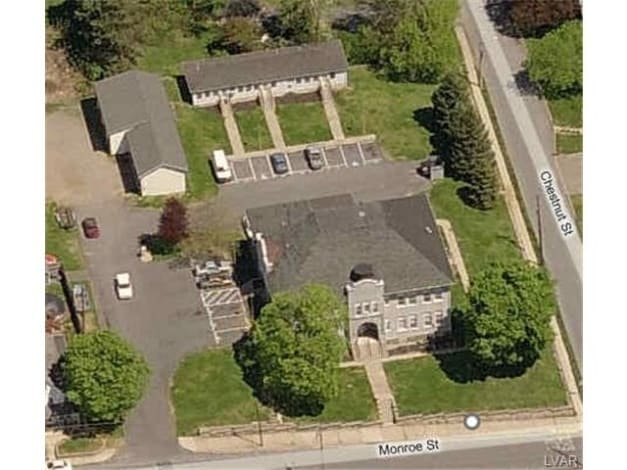
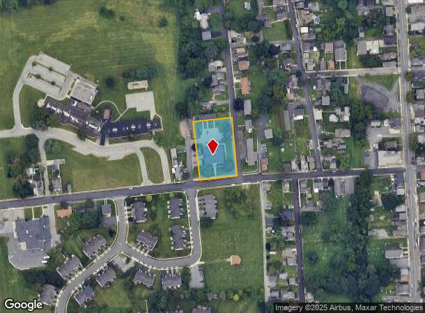
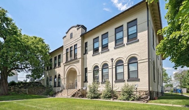
Property Record
321 Monroe St, Freemansburg, PA 18017

NEARBY LISTINGS FOR SALE OR LEASE
-
-
-
-
No Photo
-
-
-
-
View all Freemansburg listings for sale on LoopNet.com
Property Detail
321 Monroe St
Apartment
Northampton
X
Pennsylvania
42095C0264E
1.01 AC
2025
E Bethlehem/W Northampton County
2025
Philadelphia
017800
Allentown-Bethlehem-Easton, PA-NJ
10,910 SF
N7SW3D-13-6-0212
DEMOGRAPHICS near 321 Monroe St
1 Mile
3 Mile
5 Mile
2024 Total Population
7,441
82,541
152,556
2029 Population
7,358
82,855
153,242
Pop Growth 2024-2029
(1.12%)
+ 0.38%
+ 0.45%
Average Age
38
40
41
2024 Total Households
2,894
31,911
59,444
HH Growth 2024-2029
(1.04%)
+ 0.48%
+ 0.52%
Median Household Inc
$46,730
$70,117
$73,783
Avg Household Size
2.50
2.40
2.40
2024 Avg HH Vehicles
2.00
2.00
2.00
Median Home Value
$183,427
$236,611
$254,774
Median Year Built
1965
1959
1965
Nearby Places
Map Layers
Map Styles
 Street
 Aerial
- Restaurants
- Banks
- Shops
- Fitness
- Groceries
PUBLIC TRANSPORTATION
AIRPORT
Lehigh Valley International
DRIVE
WALK
Distance
Lehigh Valley International
17 min
8.0 mi
Trenton Mercer
DRIVE
WALK
Distance
Trenton Mercer
84 min
46.1 mi
Freight Ports
Port of Philadelphia
DRIVE
WALK
Distance
Port of Philadelphia
92 min
53.5 mi
SALE & LEASE HISTORY
LISTING DATE
SALE/LEASE

Aug 07, 2017
For Sale
Nearby Properties
Address
Land Use
TOTAL SIZE
Lot Size
Zoning
Address
Land Use
TOTAL SIZE
Lot Size
Zoning
425,507 SF
52.58 AC
HI
Address
Land Use
TOTAL SIZE
Lot Size
Zoning
1,197,396 SF
57.03 AC
HI
Address
Land Use
TOTAL SIZE
Lot Size
Zoning
12,838 SF
36.50 AC
IP
Address
Land Use
TOTAL SIZE
Lot Size
Zoning
1,200,000 SF
107.27 AC
HI
Address
Land Use
TOTAL SIZE
Lot Size
Zoning
1,710,800 SF
68.08 AC
HI
Address
Land Use
TOTAL SIZE
Lot Size
Zoning
148,804 SF
22.75 AC
OB
Address
Land Use
TOTAL SIZE
Lot Size
Zoning
26,653 SF
13.51 AC
HI
Address
Land Use
TOTAL SIZE
Lot Size
Zoning
11,856 SF
454.48 AC
CM
Address
Land Use
TOTAL SIZE
Lot Size
Zoning
800,280 SF
18.20 AC
HI
Address
Land Use
TOTAL SIZE
Lot Size
Zoning
332,641 SF
2.27 AC
HI
Address
Land Use
TOTAL SIZE
Lot Size
Zoning
800,250 SF
40.07 AC
HI
Address
Land Use
TOTAL SIZE
Lot Size
Zoning
676,788 SF
39.39 AC
HI
Address
Land Use
TOTAL SIZE
Lot Size
Zoning
3,400 SF
65.07 AC
RM
Address
Land Use
TOTAL SIZE
Lot Size
Zoning
10,572 SF
54.17 AC
IP
Address
Land Use
TOTAL SIZE
Lot Size
Zoning
230,780 SF
14.48 AC
I
Address
Land Use
TOTAL SIZE
Lot Size
Zoning
421,883 SF
34.66 AC
HI
Address
Land Use
TOTAL SIZE
Lot Size
Zoning
347,514 SF
10.27 AC
RM
Address
Land Use
TOTAL SIZE
Lot Size
Zoning
168,984 SF
20.31 AC
I
Address
Land Use
TOTAL SIZE
Lot Size
Zoning
31,442 SF
9.87 AC
IP
Address
Land Use
TOTAL SIZE
Lot Size
Zoning
319,788 SF
60 AC
IN
Address
Land Use
TOTAL SIZE
Lot Size
Zoning
63,711 SF
31.56 AC
RR
Address
Land Use
TOTAL SIZE
Lot Size
Zoning
24,354 SF
11.16 AC
HI
Address
Land Use
TOTAL SIZE
Lot Size
Zoning
103,214 SF
2.55 AC
RT
Address
Land Use
TOTAL SIZE
Lot Size
Zoning
809,830 SF
25.68 AC
HI
Address
Land Use
TOTAL SIZE
Lot Size
Zoning
809,830 SF
21.93 AC
HI
Address
Land Use
TOTAL SIZE
Lot Size
Zoning
20,000 SF
2.81 AC
HI
Address
Land Use
TOTAL SIZE
Lot Size
Zoning
536,726 SF
12.02 AC
HI
Address
Land Use
TOTAL SIZE
Lot Size
Zoning
208,053 SF
45.58 AC
I
Address
Land Use
TOTAL SIZE
Lot Size
Zoning
209,356 SF
3.43 AC
I
Address
Land Use
TOTAL SIZE
Lot Size
Zoning
75,833 SF
10.64 AC
IP
The World's #1 Commercial Real Estate Marketplace
Connect with us
© 2025 CoStar Group
The information above has been obtained from sources believed reliable. While we do not doubt its accuracy we have not verified it and make no guarantee, warranty or representation about it. It is your responsibility to independently confirm its accuracy and completeness. Any projections, opinions, assumptions, or estimates used are for example only and do not represent the current or future performance of the property. The value of this transaction to you depends on tax and other factors which should be evaluated by your tax, financial, and legal advisors. You and your advisors should conduct a careful, independent investigation of the property to determine to your satisfaction the suitability of the property for your needs.